


Voting District ATHENS EAST, Athens County, Ohio
About
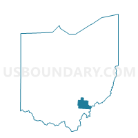
Outline

Summary
| Unique Area Identifier | 642823 |
| Name | Voting District ATHENS EAST |
| County | Athens County |
| State | Ohio |
| Area (square miles) | 8.03 |
| Land Area (square miles) | 7.86 |
| Water Area (square miles) | 0.18 |
| % of Land Area | 97.82 |
| % of Water Area | 2.18 |
| Latitude of the Internal Point | 39.35426600 |
| Longtitude of the Internal Point | -82.08632350 |
Maps


Graphs
Select a template below for downloading or customizing gragh for Voting District ATHENS EAST, Athens County, Ohio


Neighbors
Neighoring Voting District (by Name) Neighboring Voting District on the Map
- Voting District ALEXANDER EAST, Athens County, OH
- Voting District AMES TOWNSHIP, Athens County, OH
- Voting District ATHENS 1-2, Athens County, OH
- Voting District ATHENS 1-3, Athens County, OH
- Voting District ATHENS 2-1, Athens County, OH
- Voting District ATHENS 2-2, Athens County, OH
- Voting District ATHENS 2-3, Athens County, OH
- Voting District ATHENS 2-4, Athens County, OH
- Voting District ATHENS 3-6, Athens County, OH
- Voting District ATHENS 3-7, Athens County, OH
- Voting District ATHENS 3-8, Athens County, OH
- Voting District ATHENS 4-1, Athens County, OH
- Voting District ATHENS 4-2, Athens County, OH
- Voting District ATHENS 4-3, Athens County, OH
- Voting District ATHENS 4-4, Athens County, OH
- Voting District ATHENS SOUTH, Athens County, OH
- Voting District CANAAN NORTH, Athens County, OH
- Voting District CANAAN SOUTH, Athens County, OH
- Voting District CIRCLE HILL, Athens County, OH
- Voting District LODI TOWNSHIP, Athens County, OH
- Voting District PLAINS 1, Athens County, OH
- Voting District SUGAR CREEK, Athens County, OH
Top 10 Neighboring County Subdivision (by Population) Neighboring County Subdivision on the Map
- Athens township, Athens County, OH (30,473)
- Dover township, Athens County, OH (3,626)
- Alexander township, Athens County, OH (2,811)
- Canaan township, Athens County, OH (1,666)
- Lodi township, Athens County, OH (1,425)
- Ames township, Athens County, OH (1,183)
Top 10 Neighboring Place (by Population) Neighboring Place on the Map
Top 10 Neighboring Unified School District (by Population) Neighboring Unified School District on the Map
- Athens City School District, OH (35,023)
- Alexander Local School District, OH (10,470)
- Federal Hocking Local School District, OH (8,100)
Top 10 Neighboring State Legislative District Lower Chamber (by Population) Neighboring State Legislative District Lower Chamber on the Map
Top 10 Neighboring State Legislative District Upper Chamber (by Population) Neighboring State Legislative District Upper Chamber on the Map
Top 10 Neighboring 111th Congressional District (by Population) Neighboring 111th Congressional District on the Map
Top 10 Neighboring Census Tract (by Population) Neighboring Census Tract on the Map
- Census Tract 9729, Athens County, OH (5,391)
- Census Tract 9733, Athens County, OH (3,721)
- Census Tract 9730, Athens County, OH (3,614)
- Census Tract 9739.02, Athens County, OH (3,494)
- Census Tract 9734, Athens County, OH (3,347)